Today, I took my friend Angie
exploring with me to three different areas that were all within an hour of her
home. Her favorite place to hike is Devil’s Lake State Park and while I
agree it’s stunning, I wanted to show her that there were other areas in Sauk
County worth seeing.
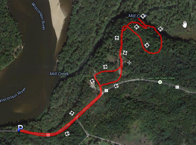
Tower Hill State Park
Our first stop was Tower Hill State
Park. Even though it’s May, the park was “closed for the season.” Surely,
they didn’t mean us. We parked a quarter mile down the highway and hiked in.

The hike was beautiful and had all
the elements I love – rock ledges, hills, views and color (I’m obsessed with
the color green right now).
We were never quite where I thought we were when we came across directional signs (perhaps the park was closed so they could fix the signs).
We were never quite where I thought we were when we came across directional signs (perhaps the park was closed so they could fix the signs).

While there are lots of areas of
historical significance in the park (something to do with manufacturing shot
for the Civil War), we were there for the views.
From the Mill Creek that ran below
to the rock ledges to the nearby swamp -- the area is pretty much stunning.
 |
| Mill Creek |
While at the park we came across a
group of five older women who were staying at the nearby House on the Rock
Resort. They were loud, chatty and entertaining (and they also felt the
“closed” sign was merely a suggestion). Angie and I saw them a few times along
our hike (not hard to do since there are less than 2 miles of trails that keep
intersecting with each other).
 |
| The trail to the shot tunnel. |
As we approached the tunnel, we
heard frantic screaming and the five women came running from it flailing and shrieking. I
wish I had it on video.
 |
| Shot Tunnel |
Apparently, there was
something living inside.
Naturally, I wanted to see for myself. I suppose it would be more apt to say I wanted to see it without seeing it.
While not afraid of the dark, I am afraid of getting attacked by things I can’t
see (you should see me in a haunted house – I scream curse words like a
trucker). As far as I could tell there was nothing here to be afraid of. It’s
Wisconsin for crying out loud. It was a
beautiful day and I was hiking with my friend. Living creatures are harmless,
right? (Don’t get me wrong, I’m not Grizzly Man, I was just convinced it was a
bunny.) I entered the cave with the assumption that Angie had my back. Of
course, I eventually learned she had my far
back and never really left the cave entrance.
 |
| Can't tell if there is anything living back in that hay. |
 |
| Angie guarding the tunnel entrance. She's got my back. |
Without a flashlight, I eventually chickened
out.
Back in the daylight, this area of
the park is incredible with the sheer number of birds flying around and rock
formations. The cliffs are filled with nests and the birds dance to the sounds
of chirping and insects.


Even though the park didn’t have
many trails to hike, and I will always wonder what the heck was in the back of
the shot tunnel, it was a lovely destination and absolutely worth the
trip. I will return with a flashlight someday.
Side note: On the hike along the
highway back to the car I saved Angie from stepping on a recently deceased
squirrel. It was not pretty. Let's just say that at least one of us has got the other's back. Just sayin'.
Ferry Bluff State Natural Area
We drove from Spring Green to the
Ferry Bluff State Natural Area using Highway 60. The drive itself is beautiful
with winding roads over rolling hills and surrounded by farmlands. For whatever reason, other drivers felt really confident with all the twists
and turns and did not appreciate the fact that I was only going 5 over the
speed limit. I am confident that the no passing zones were making the
other drivers agitated. I eventually found a driveway to pull into and let all
the suicidal drivers go by.
Ferry Bluff State Natural Area was
not as easy to find as I had hoped, mostly because it’s not marked along the
highway.
As a matter of fact the only reason
we found it is because Angie mentioned how interesting it was to pass a street
named after the place we were going to.
Cue u-turn.

It’s
gravel and one lane and there are no parking spots at the end. You merely have to park along the roadside
and hope people leave enough room to let you out when your done with your hike.
The hike is short (less than a half
mile) and pretty much goes up to the top of the bluff. People have told me how
easy this hike is; however, I would not recommend it for everyone – like leave
grandma and grandpa at home. It’s kind of steep (although not nearly as
steep as some of the other hikes I’ve done over the past few weeks – Perrot
State Park comes to mind).

You can see for miles standing along a rock ledge 300 feet
over the Wisconsin River.

The trees are green and the water was
absolutely perfect. No one else was there when Angie and I arrived at the top so
we simply sat along the ledge and enjoyed the view while we each took about a
dozen identical photos.

After we hiked back down, we took a
similarly short path along the riverbed.


Back
at the dead end of Ferry Bluff Road, I maneuvered a 6-point turn to get out of my
parking spot and we were off to our next stop.
How do so many people know about this place?
How do so many people know about this place?
Natural Bridge State Park
I confess I had somewhat low
expectations of Natural Bridge State Park. The significance of this park
is its history. Archaeologists found artifacts of people living there dating back 12,000 years. While that is impressive, it’s not necessarily going to
make for a pretty hike.
As it turns out the area is charming
and serene; albeit, pretty much in the middle of nowhere.

The park is named for the stone arch
that crosses over the home of the ancient dwellers. The arch is a cool
marvel to see (even if you can’t climb on or over it). It’s covered in
initials and names as numerous generations have carved their marks into the
limestone.


As it turns out there were lots of
families with kids and dogs in the area so we did not stay long.
Angie and I also hiked up a very
steep embankment to a scenic overlook (only to discover we were not on the
actual path and the way we took was much harder than it needed to be).
 |
| Not a path |
The view was mediocre. It was hard to focus on it because a couple lay on the ground canoodling
on the other side of the fence covered in “Stay on the Trail” signs. Aca-awkward.
 |
| Below this photo's edge is a canoodling couple. |
Other than the cozy couple, it was a
great and full day.
 |
| Angie and me |
STATS:
Tower Hill State Park
Trailhead Location: Hiked in from
small parking lot on CTH C, Tower Hill is located at 5808 CTH C, Spring Green,
WI 53588
Trails Hiked: Hard to say
Elevation Gain: 253 feet
Distance: 2.25 miles
Time: 1 hour (including photo ops)
Type of Trail: Loop
Temperature: 70 degrees and sunny

Ferry Bluff State Natural Area
Trailhead Location: Ferry Bluff
Road, Sauk City, WI 53583
Trails Hiked: Bluff and River Trails
Elevation Gain: 246 feet
Distance: 1.15 miles
Time: 35 minutes (including photo
ops)
Type of Trail: Out and Back
Temperature: 73 degrees and sunny


Natural Bridge State Park
Trailhead Location: Natural Bridge
State Park, E7792 CTH C, North Freedom, WI 53951
Trails Hiked: Indian Moccasin Nature
Trail
Elevation Gain: 167 feet
Distance: 1 mile
Time: 30 minutes (including photo
ops)
Type of Trail: Loop
Temperature: 75 degrees and sunny
